This is a bit disjointed & disorganized, but I wanted to get down a few stories & thoughts about Taiwan before it starts to fade. So here goes – things about Taiwan that make me smile.
Read more
Category: Taiwan
Missing the hot springs of Taiwan (and Japan)
A long cold winter has me pining for the wonderful warmth & relaxation that comes from a day visiting hot springs.
My first exposure to hot springs was the onsen culture of Japan. Starting slowly, at an indoor facility in Osaka called Spa World (check out Mike’s review here), both Mike and I quickly got over our reservations about being naked in (gender segregated) public, and became onsen converts! After Spa World, we took every opportunity we could to relax in the lovely hot water.
Taiwan is very tectonically active, and one of the consequences of this is a multitude of geothermal hot springs, and a hot spring culture that is very similar to that in Japan. A visit to the steamy waters is especially welcome during the rainy winter.
Beitou is one of the most famous examples of hot springs in Taiwan, and Mike and I really enjoyed our visit there. It was especially fun, because not only can you enjoy a soak in wonderful warm water, but you can take a walk down to the geothermal pools of the Thermal Valley, something we weren’t able to see for ourselves in Japan. The hot spring pool is stunning, with temperatures reaching 100°C, and pH values as low as 1.2. You can smell the sulphur well before you can even see the steam rising from the surface of the hot spring pools.
The valley is the discovery site of hokutolite, a variety of the mineral barite. Hokutolite was discovered in 1905 by a Japanese mineralogist, and it only forms in hot spring environments. The mineral gained a reputation for having curative powers, and was removed from the valley in large amounts. Unfortunately, while it doesn’t have any curative powers, it does precipitate at a very slow rate. It was removed in such quantites that the mineral is now protected, and the best examples in Beitou are at the Beitou Hot Spring Museum.
On our visit to Beitou, we first took some time to walk around the town, and then we rented a spa room for a couple of hours for a mid day soak and rest. Beitou is a really enjoyable and easy day trip from Taipei – the Xinbeitou station is within easy walking distance of all the fun. I highly reccomend a trip to the area for anyone who hasn’t experienced hot springs, or is looking for a neat day trip away from Taipei.
And as for me, perhaps there will be a visit to the Scandinavian Spa at Blue Mountain in my future…
Earthquakes!
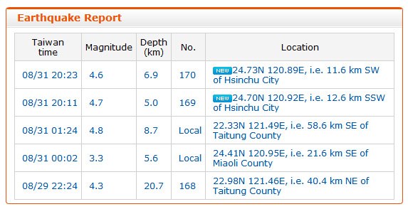
Although there were (very) minor earthquakes while I lived in Toronto, I cannot say I ever felt one. My experience in Taiwan, however, was a completely different story. Located near the ring of fire, earthquakes are very common there. In fact, it only took about a month to experience one! I was so excited, I even took a screen shot of the reporting online (the two events marked “new” in the image below):

Although a very minor event, I still remember it clearly. I was at home, on the 8th floor of an apartment building. The sensation was something akin to being on a very big boat, and the TV wobbled dramatically on its swivel stand. I must admit that I had not considered the proper actions to take in the event of an earthquake before the event, and I was quite relieved when the shaking eased off. I decided I should do some reading on earthquake preparedness for next time, when a second event occurred only a little more than 10 minutes later! Interestingly, Mike, who was out on a scooter at the time, felt nothing.
Although common events, the vast majority of the earthquakes we experienced were magnified by the elevation of our apartment and would have been difficult to detect at ground level. We also discovered that they are much easier to detect lying down than standing up, and it is quite difficult to discern a tremor from rough pavement when driving. Still, we experienced two events that were easily felt on the ground-floor in Hualien, a very seismically active area. This was a much different experience than being elevated – it was much rougher, and felt more like the Earth was cracking apart, rather than a gentle sway.
I am thankful for my easy earthquake experiences in Taiwan – thrilling and consequence free. According to the Central Weather Bureau, Taiwan experiences 2200 earthquakes a year on average, about 200 of which are felt on the ground. And occasionally they are devastating. Case in point, an earthquake registering 7.6 on the Richter Scale, that occurred on September 21, 1999, now known as the 921 Earthquake. The 921 Earthquake occurred along the Chelongpu Fault in Nantou County. More than 2300 people were killed, and thousands of others were injured. Thousands of buildings were damaged, and a 7 m waterfall was created by movement on the Chelongpu Fault. A high school lying on the fault line has been converted into the 921 Earthquake Museum where tourists can learn about earthquakes and disaster preparedness, and see some of the damage of the 921 Earthquake first hand. We never made it out there, but I would try to go the next time I’m in Taiwan.
Bonus:
Want to follow seismic activity in Taiwan? Check out the Central Weather Bureau’s Earthquake page.
The Effects of Altitude
Taiwan’s mountains are huge! Seeing the peaks poke through the clouds flying in and out of Taipei gives you a little taste of their size, but even more impressive is their highest mountain pass. The highest mountain in Taiwan is Yushan (玉山) at 3952 m, and the highest mountain pass crosses Hehuanshan (合歡山) at 3275 m. In contrast, while Mt. Logan, the highest mountain in Canada, tops out at 5959 m, the highest mountain pass (Highwood) is at a measly 2206 m.
Mike and I enjoy a good hike up a mountain, and tackle them whenever we can. Sadly, we were too early in the season to attempt Mt. Fuji, but we did summit Hallasan on Jeju Island, South Korea. Check out the graphic to compare some of the peaks we’ve summited, and the highest peaks in Canada and Taiwan.

As part of our time resting and exploring Hualien, we rented scooters and drove up to Wuling and the Hehuashan pass. The drive from Hualien to the top is about 100 km of engaging driving and stunning scenery. The marble canyons and gushing river at the foot of the mountains give way to precarious and seemingly never ending winding roads and tunnels further up. Finally, the forest gives way, and scrub takes over. The last 10 km of driving or so looks like it could be Wales or somewhere in Newfoundland. It is interesting to note that despite the altitude, the peaks are not perennially snow-capped. Still, anyone curious about the white fluffy stuff can visit in the winter months and hope for a heavy snow fall.
At such a high elevation, the reduced amount of oxygen in the air noticeably affects the performance of your scooter. So much so that you nearly have to push it up some of the inclines! I didn’t notice the effects on my breathing while I was driving, but I felt light headed and winded the moment I parked and started walking. At the mountain top resorts, there were plenty of signs indicating medication for acute altitude sickness was available, and I can see why. Altitude effects are quite common over 3000 m, and Mike felt it too. I still can’t believe Mike cycled to the summit the very next day – a physical challenge even without the thin air!
Our time on Hehuanshan is the only time I have ever felt the effects of altitude, and it stands out as an amazing experience in Taiwan. I certainly have a newfound respect for mountaineers!
Rainy Days, the Monsoon and Taiwan
The word ‘monsoon’ may conujure up images of warm tropical rains, however the term monsoon refers to a seasonal wind that reverses direction during the year. The summer monsoon is typically a rainy season, whereas the the winter monsoon is typically dry. This is because during the summer, the Asian landmass gets heated by the Sun. This creates a low pressure zone over the land that draws in wet oceanic air which results in heavy rainfall and potential flooding. In the winter, the system reverses itself. As the land cool down, a high pressure system develops and cold dry air is pushed out toward the ocean.

In Taiwan, this story is complicated by the Central and Xueshan mountain ranges. The winter monsoon is blocked by these mountains, resulting in cloudy weather and orographic precipitation over northern Taiwan during the winter months, while southern Taiwan stays dry. The summer monsoon is rainy throughought Taiwan, and can be divided into three components. First, there is a rainy period in May called 梅雨 (Meiyu = Plum Rain). This is followed by a break in the rain, and then another rainy period that extends from July to September.
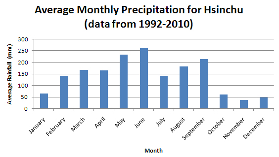
The winds were a big player in our decision to travel clockwise around the island when we went on our cycling trip – depending on the season, it can be better to go one way or the other. The rains that come with the summer monsoon were also pretty neat. Every afternoon you could count on a downpour (better keep a poncho in the scooter boot)! Hsinchu is in the north, so we also experienced winter monsoon rains. These were a little less enjoyable since getting wet in the 10 degree weather would sometimes get a little chilly. I worked out early on that flip-flops were a great alternative to dealing with wet running shoes during the winter rains. Here’s a chart showing average monthly precipitation in Hsinchu, prepared using data from 1992-2010 from the Central Weather Bureau:

Extra reading: some neat papers about precipitation in Taiwan
- Yijui, Ding, Johnny C.L. Chan, 2005: The East Asian summer monsoon: an overview Meteorol. Atmos. Phys. 89, 117-142.
- The Redefinition of Taiwan Seasons
- Yen, Ming-Chen, Tsing-Chang Chen, 2000: Seasonal Variation of the Rainfall Over Taiwan Int. J. Climatol. 20, 803-809.
- Chen, Ching-Sen, Yi-Leng Chen, 2003: The Rainfall Characteristics of Taiwan Mon. Wea. Rev. 131, 1323-1341.
- Hung, Chih-wen, Pei-ken Kao, 2010: Weakening of the Winter Monsoon and Abrupt Increase of Winter Rainfalls over Northern Taiwan and Southern China in the Early 1980s J. Climate, 23, 2357–2367.
Rain, wind and waves… Typhoons!

Typhoons are the the Northwestern Pacific’s equivalent to the hurricanes that occur in the Northeastern Pacific and Atlantic. They are formed when a number of factors (including a warm ocean and an existing weather disturbance) come together. When a typhoon makes landfall, it can bring high winds, torrential rain, huge waves and flooding.
Heavy rains and the occasional windy weekend were all the effects of hurricanes I ever experienced in Ontario, but I did experience Hurricane Igor in St. John’s, Newfoundland. While the storms themselves are similar to what Igor was, the frequency with which they arrive is amazing. There have only been 13 hurricanes that made landfall in Newfoundland since 1775, but Taiwan experiences about 2 or 3 a year! This, of course, means that there is much infrastructure put in place to deal with such storms, such as huge floodways and bridges that seem to be taller than one might think they need to be.
We experienced a few typhoons, the most serious of which was Soulik, which caused 4 fatalities, and among other things, the largest offset ever recorded at the mass damper in Taipei 101. For us, the winds seemed similar or less severe than those we experienced during Igor, but the amount of rainfall was absolutely astounding.
Comparing Igor and Soulik:
| Igor St. John’s Airport |
Soulik Hsinchu |
|
| Total Rainfall (mm) | 120 | 823 (Bailan Township) |
| Peak Wind Gusts (km/h) | 137 | 104 |
You can track typhoons near Taiwan through the Central Weather Bureau Typhoon Advisory page.
Check out excellent photographer (and my soccer teammate) Colin Peddle’s photojournal capturing the destruction of Hurricane Igor and a BBC summary of Typhoon Soulik (plus video).
Cycling the West Coast of Taiwan
Many people recommend starting with the West coast of Taiwan and moving counter-clockwise when riding around the island. There are a few reasons for this – the higher population means more places to stop and fuel up and stay overnight, and more English speakers also helps with easing yourself into the Taiwan way of life, if you’re just visiting short term. It is also much flatter than the East, albeit most of the riding is along a pretty busy highway.
Cycling the East Coast of Taiwan

The East coast of Taiwan, land of big bike lanes and amazing views. Read on…
Cycling the Northern Cross Highway
In addition to taking the coastal road that skirts around the edge of Taiwan, there are a few mountain passes as well. We planned to tackle the northernmost road that crosses the mountains, Highway 7, aka the Northern Cross Highway. Our route took us from Hsinchu to Luodong (near Yilan), via Guanxi and Baling, a total of about 160 km. The mountain pass topped out at 1170 m elevation, and Baling and Guanxi are spaced in a way that breaks up the climb nicely.
騎自行車台湾環島 / Cycling Around the Island of Taiwan
As I wrote before, the day after I finished teaching at Royal we packed up our bags and started to cycle around Taiwan, something referred to here as 環島 (huandao), meaning ‘circle the island’.
Our trip can be neatly broken down into three sections: 1) the northern cross highway over the mountains; 2) the east coast and 3) the west coast. I want to write about it in some detail for any future interested cyclists, so I will break it down into three posts based on those divisions. But before we get there…